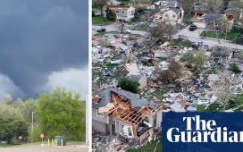
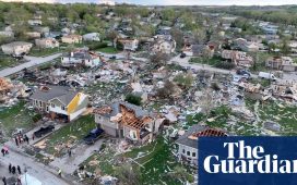
Volatile weather is expected to hone in on parts of Kansas and Missouri Wednesday night, and the biggest worry is the potential for massive chunks of hail.
Some are calling it “gorilla hail” because it has the potential to be so big, said Alex Sosnowski, senior meteorologist at AccuWeather. The Kansas City metro area is at the center of the worry zone.
“Gorilla hail” is a term coined by Reed Timmer, a storm chaser who calls himself an extreme meteorologist, Sosnowski said. In this case, the term might fit: some hail from north-central Kansas into north-central Missouri could be as big as a baseball.
“When you get up to tennis ball-, baseball-sized or God forbid softball-sized, that can do a tremendous amount of damage, and if you get hit in the head, that could be fatal,” Sosnowski said.
Cars are especially vulnerable to damage, so Sosnowski encouraged people to try to find a place to park under a roof, if possible.
Beyond the hail, heavy rain is possible in the same corridor. The National Weather Service warned of a risk of flash flooding.
A slight threat exists for tornadoes.
By Thursday, the storm will move to the east, forecasters said. The hail threat will lessen, but heavy rain and high winds still are possible from north-eastern Texas through central Missouri.
The biggest threat on Friday is torrential rain – perhaps up to 4ins (10.16cm) in some spots – in a line from central Louisiana up through central Arkansas, Sosnowski said.


