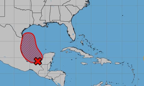
A tropical depression may form next week in the Gulf of Mexico, according to the National Hurricane Center.
In a forecast on Saturday afternoon, the NHC said that an area of low pressure had formed over the Bay of Campeche in the southern area of the Gulf of Mexico. It had been producing disorganized showers and thunderstorms.
The system is expected to slowly drift northward for several days, and a tropical depression is likely to form during the early or middle part of next week as the system moves near or along Mexico’s and Texas’s Gulf coastline, the NHC said.
According to the NHC, the chance of formation in the next 48 hours is at 50% while the chance of formation through the next seven days is at 70%.
It remains unclear how strong the tropical depression will be. The Gulf of Mexico is warm this time of year, and the temperatures can help storms strengthen.
The climate crisis, primarily driven by the burning of fossil fuels, is also warming the world’s oceans at a record pace. Storms that intensify rapidly are occurring more frequently, too, leaving coastal communities vulnerable.
Typically, tropical depressions – which are a type of tropical cyclone – have a maximum sustained surface wind speed of up to 38mph.
Should the tropical depression develop into a tropical storm, it will be named Francine, the Austin American-Statesman reported. The system by Saturday had been dousing Texas and Louisiana with heavy rains for days.
“The northern flank of that system is moving into the extreme southern Gulf of Mexico,” Bryan Norcross, a Fox Weather hurricane specialist, said. “The non-tropical low-pressure system and its associated front, which together have been dousing Texas and Louisiana with heavy rain, are the second components.
“An approaching cold front that will move into the Gulf [on Saturday] is the third.”
In addition to the potential tropical depression in the Gulf of Mexico, the NHC has been tracking an area of low pressure over the central tropical Atlantic, which has also been producing disorganized showers and thunderstorms.
In its forecast, the NHC said that the system is expected to gradually develop while it meanders during the next couple of days. A tropical depression may also form early next week, and it is predicted to move west-northward at about 10mph across the central tropical Atlantic during the middle to latter part of next week.
According to the NHC, the chance of formation of this tropical depression between Saturday and Monday was low, at 10%. The chance of formation over the next week, as of Saturday, stood at 40%.

